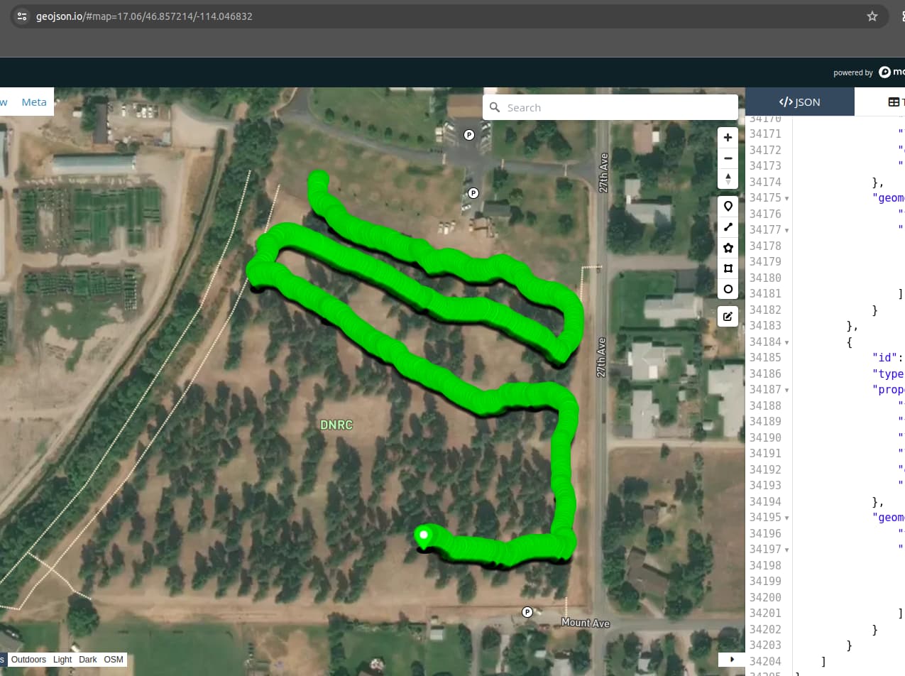
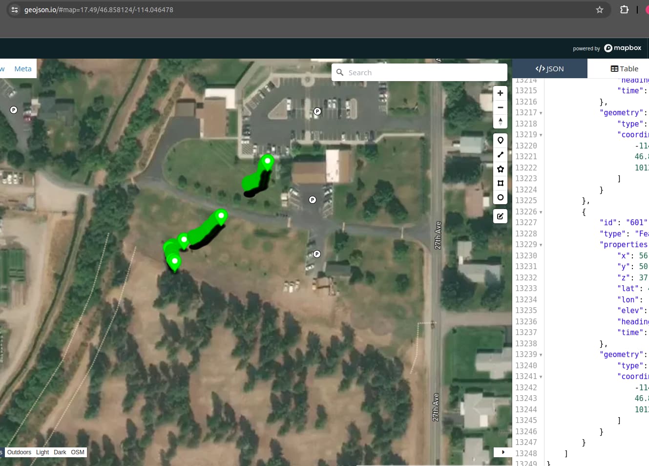
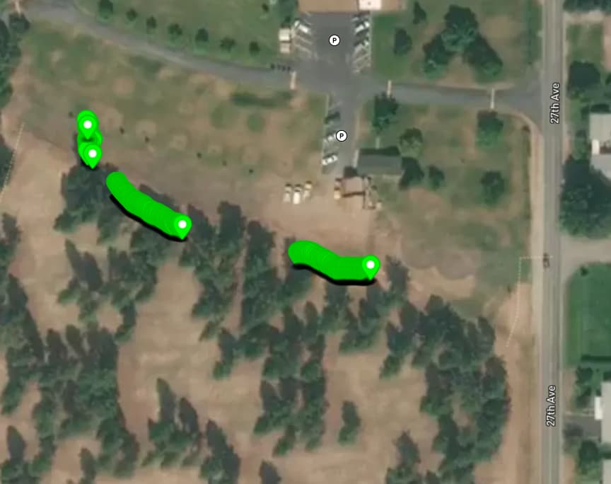
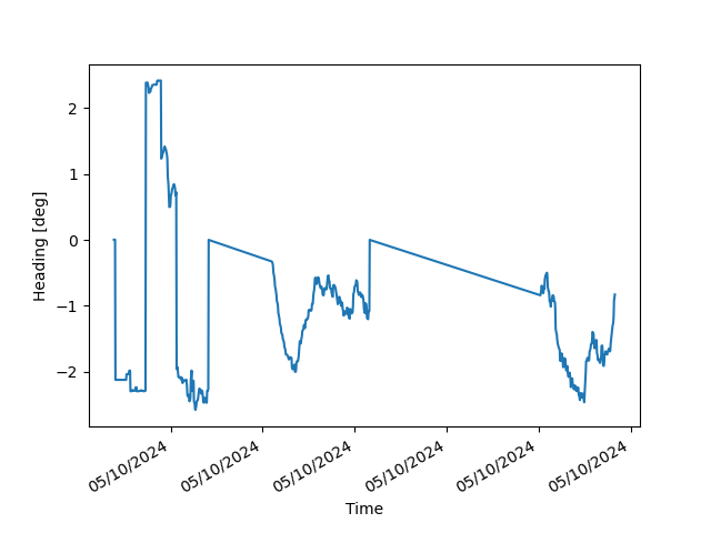
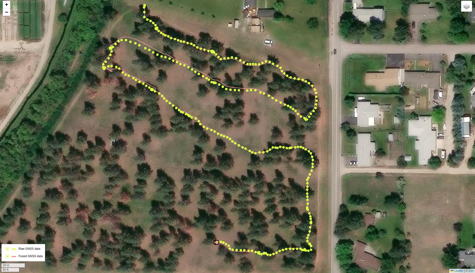
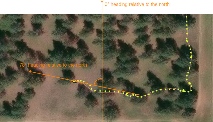
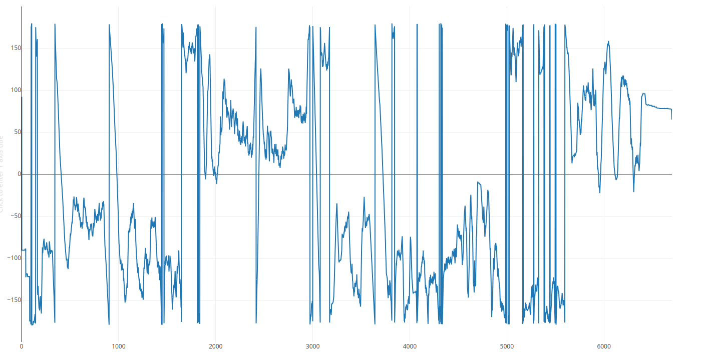
I am attempting to perform SLAM with VIO/GNSS Fusion. After a a few minutes, my positional uncertainty as given by fusion.get_current_gnss_calibration_std() becomes quite large (> 1e19) and my calibration becomes off. Could this be some oversight on my end with GNSS ingestion?
Note that uncertainties will be printed to the terminal
Data:
https://drive.google.com/file/d/1XxqANF3J-y4Q6GYiCN7eC22UHCCcZ8Kr/view?usp=sharing
Code:
# THIS SOFTWARE IS PROVIDED BY THE COPYRIGHT HOLDERS AND CONTRIBUTORS
# "AS IS" AND ANY EXPRESS OR IMPLIED WARRANTIES, INCLUDING, BUT NOT
# LIMITED TO, THE IMPLIED WARRANTIES OF MERCHANTABILITY AND FITNESS FOR
# A PARTICULAR PURPOSE ARE DISCLAIMED. IN NO EVENT SHALL THE COPYRIGHT
# OWNER OR CONTRIBUTORS BE LIABLE FOR ANY DIRECT, INDIRECT, INCIDENTAL,
# SPECIAL, EXEMPLARY, OR CONSEQUENTIAL DAMAGES (INCLUDING, BUT NOT
# LIMITED TO, PROCUREMENT OF SUBSTITUTE GOODS OR SERVICES; LOSS OF USE,
# DATA, OR PROFITS; OR BUSINESS INTERRUPTION) HOWEVER CAUSED AND ON ANY
# THEORY OF LIABILITY, WHETHER IN CONTRACT, STRICT LIABILITY, OR TORT
# (INCLUDING NEGLIGENCE OR OTHERWISE) ARISING IN ANY WAY OUT OF THE USE
# OF THIS SOFTWARE, EVEN IF ADVISED OF THE POSSIBILITY OF SUCH DAMAGE.
#
########################################################################

"""
    This sample shows how to fuse the position of the ZED camera with an external GNSS Sensor
"""

import sys
import pyzed.sl as sl
import json
from datetime import datetime
import cv2
import numpy as np
from typing import Tuple
import matplotlib.pyplot as plt

def gnss_str_to_pyzed(data:str) -> sl.GNSSData:

    # '{"timestamp":"2024-05-06T20:13:09+00:00",
    # "time_delta":0,
    # "lat":46.8655633,"lon":-113.975665,
    # "elevation":985.933,
    # "covariance":"[34.727449, 0.0, 0.0, 0.0, 47.651408999999994, 0.0, 0.0, 0.0, 1.940449]"}'
    #
    data = json.loads(data)
    gps_data = sl.GNSSData()

    sl_fix_mode = sl.GNSS_MODE.FIX_3D
    sl_status = sl.GNSS_STATUS.RTK_FIX
    gps_data.gnss_mode = sl_fix_mode.value
    gps_data.gnss_status = sl_status.value

    date_time = datetime.fromisoformat(data["timestamp"])
    zed_ts = sl.Timestamp()
    zed_ts.set_nanoseconds(int(date_time.timestamp()*1e9))
    gps_data.ts = zed_ts
    gps_data.set_coordinates(data["lat"],data["lon"],data["elevation"],False)
    covariances = json.loads(data["covariance"])
    gps_data.position_covariances = [float(x) for x in covariances]
    return gps_data

if __name__ == "__main__":

    gnss_measurements = []
    fused_position_measurements = []
    fused_geopose_measurements = []

    cv2.namedWindow("RGB",cv2.WINDOW_NORMAL)

    filepath = "camera_recording_0.svo2"

    input_type = sl.InputType()
    input_type.set_from_svo_file(filepath)  #Set init parameter to run from the .svo

    init = sl.InitParameters(input_t=input_type, svo_real_time_mode=False,camera_resolution=sl.RESOLUTION.AUTO,
                                 coordinate_units=sl.UNIT.METER,
                                 coordinate_system=sl.COORDINATE_SYSTEM.RIGHT_HANDED_Z_UP)

    init.depth_mode = sl.DEPTH_MODE.PERFORMANCE
    zed = sl.Camera()
    status = zed.open(init)
    if status != sl.ERROR_CODE.SUCCESS: #Ensure the camera opened succesfully
        print("Camera Open", status, "Exit program.")
        exit(1)


    print('External SVOData channels:', zed.get_svo_data_keys())

    # some variables
    odometry_pose = sl.Pose()
    odometry_pose = sl.Pose()
    py_translation = sl.Translation()
    pose_data = sl.Transform()
    rgb = sl.Mat()
    text_translation = ""
    text_rotation = ""
    current_gnss = sl.GNSSData()
    current_geopose = sl.GeoPose()
    # Create a ZED camera object


    # set up communication parameters and start publishing
    communication_parameters = sl.CommunicationParameters()
    communication_parameters.set_for_shared_memory()
    zed.start_publishing(communication_parameters)

    # warmup for camera
    if zed.grab() != sl.ERROR_CODE.SUCCESS:
        print("Camera grab: " + repr(status) + ". Exit program.")
        exit()
    else:
        zed.get_position(odometry_pose, sl.REFERENCE_FRAME.WORLD)

    tracking_params = sl.PositionalTrackingParameters()
    # These parameters are mandatory to initialize the transformation between GNSS and ZED reference frames.
    tracking_params.enable_imu_fusion = True
    tracking_params.set_gravity_as_origin = True
    err = zed.enable_positional_tracking(tracking_params)
    if (err != sl.ERROR_CODE.SUCCESS):
        print("Camera positional tracking: " + repr(status) + ". Exit program.")
        exit()
    camera_info = zed.get_camera_information()

    # step 2
    # init the fusion module that will input both the camera and the GPS
    fusion = sl.Fusion()
    init_fusion_parameters = sl.InitFusionParameters()
    init_fusion_parameters.coordinate_system = sl.COORDINATE_SYSTEM.RIGHT_HANDED_Y_UP
    init_fusion_parameters.coordinate_units = sl.UNIT.METER
    gnss_calibration_params = sl.GNSSCalibrationParameters()
    gnss_calibration_params.gnss_vio_reinit_threshold = 5
    fusion.init(init_fusion_parameters)
    positional_tracking_fusion_parameters = sl.PositionalTrackingFusionParameters()
    positional_tracking_fusion_parameters.enable_GNSS_fusion = True
    positional_tracking_fusion_parameters.gnss_calibration_parameters = gnss_calibration_params
    fusion.enable_positionnal_tracking(positional_tracking_fusion_parameters)
    print(gnss_calibration_params)
    uuid = sl.CameraIdentifier(camera_info.serial_number)
    print("Subscribing to", uuid.serial_number, communication_parameters.comm_type) #Subscribe fusion to camera
    status = fusion.subscribe(uuid, communication_parameters, sl.Transform(0,0,0))
    if status != sl.FUSION_ERROR_CODE.SUCCESS:
        print("Failed to subscribe to", uuid.serial_number, status)
        exit(1)

    x = 0

    i = 0

    if zed.grab() == sl.ERROR_CODE.SUCCESS:
        zed.get_position(odometry_pose, sl.REFERENCE_FRAME.WORLD)
        zed.retrieve_image(rgb, sl.VIEW.LEFT)
        rgb_img = cv2.cvtColor(rgb.get_data(), cv2.COLOR_RGBA2RGB)
        last_timestamp = rgb.timestamp
        cv2.imshow("RGB",rgb_img)

    while i < 1e7:
        # get the odometry information
        if zed.grab() == sl.ERROR_CODE.SUCCESS:
            zed.get_position(odometry_pose, sl.REFERENCE_FRAME.WORLD)
            zed.retrieve_image(rgb, sl.VIEW.LEFT)
            rgb_img = cv2.cvtColor(rgb.get_data(), cv2.COLOR_RGBA2RGB)
            cv2.imshow("RGB",rgb_img)

        elif zed.grab() == sl.ERROR_CODE.END_OF_SVOFILE_REACHED:
            break


        ts_camera : sl.Timestamp = rgb.timestamp

        data_map = {}
        ing = zed.retrieve_svo_data("GNSS",data_map,last_timestamp,ts_camera)
        data_map = [(k,v) for k,v in data_map.items()]
        for data in data_map:
            data_string = data[1].get_content_as_string()
            gnss_data = gnss_str_to_pyzed(data_string)

            time_delta = ts_camera.get_microseconds() - gnss_data.ts.get_microseconds()


            status = fusion.ingest_gnss_data(gnss_data)
            if status.name == "SUCCESS":
                gnss_measurements.append(
                    [gnss_data.get_coordinates(False)]
                )

        last_timestamp = ts_camera


        # get the fused position
        if fusion.process() == sl.FUSION_ERROR_CODE.SUCCESS:

            fused_tracking_state = fusion.get_position(odometry_pose, sl.REFERENCE_FRAME.WORLD)
            if fused_tracking_state == sl.POSITIONAL_TRACKING_STATE.OK:

                rotation = odometry_pose.get_rotation_vector()
                translation = odometry_pose.get_translation(py_translation)
                fused_position_measurements.append(translation.get())

                # get geopose

                gp_status = fusion.get_geo_pose(current_geopose)
                if gp_status.name == "OK":
                    fused_geopose_measurements.append(
                        current_geopose.latlng_coordinates.get_coordinates(False)
                        )
                process_metrics: Tuple[sl.FUSION_ERROR_CODE,sl.FusionMetrics] = fusion.get_process_metrics()
                fusion_error_code, fusion_metrics = process_metrics
                fusion_metrics = {"mean_camera_fused":np.round(fusion_metrics.mean_camera_fused,3),"mean_stdev_camera_ts":np.round(fusion_metrics.mean_stdev_between_camera,3)}


                vio_gnss_trns: sl.Transform = fusion.get_geo_tracking_calibration()
                vio_gnss_trns_translation:np.ndarray = vio_gnss_trns.get_translation().get()

                gnss_calibration_data: Tuple[sl.GNSS_FUSION_STATUS,float,np.ndarray] = fusion.get_current_gnss_calibration_std()
                gnss_status, yaw_unc, pos_unc = gnss_calibration_data


                out = {
                    "fusion_error_code": fusion_error_code.name,
                    "fusion_metrics": fusion_metrics,
                    "vio_gnss_trns": [np.round(x,3) for x in vio_gnss_trns_translation.tolist()],
                    "gnss_calibration":gnss_status.name,
                    "yaw_unc": np.round(yaw_unc,3),
                    "pos_unc": [np.round(x,3) for x in pos_unc.tolist()]

                }
                print(out)

        i = i + 1
        if cv2.waitKey(1) & 0xFF == ord('q'):
            break

    zed.close()


    # Assuming gnss_measurements and fused_geopose_measurements are lists of [lat, lon] pairs
    gnss_lats, gnss_lons = zip(*gnss_measurements)
    fused_lats, fused_lons = zip(*fused_geopose_measurements)

    # Assuming fused_position_measurements is a list of [x, y, z] coordinates
    fused_xs, fused_ys, fused_zs = zip(*fused_position_measurements)

    fig, axs = plt.subplots(2)

    # Plot lat, lon from gnss_measurements and fused_geopose_measurements
    axs[0].plot(gnss_lats, gnss_lons, label='GNSS Measurements',color='r')
    axs[0].plot(fused_lats, fused_lons, label='Fused Geopose Measurements',color='b')
    axs[0].set_xlabel('Latitude')
    axs[0].set_ylabel('Longitude')
    axs[0].legend()

    # Plot fused_position_measurements
    axs[1].plot(fused_xs, fused_ys, label='Fused Position Measurements')
    axs[1].set_xlabel('X')
    axs[1].set_ylabel('Y')
    axs[1].legend()

    plt.show()